
A lakefront photograph captures one day. A home has to work for the seasons you intend to use it. If you are looking around Weiss Lake, that difference deserves a place in the home search alongside the house, the road and the view. An autumn visit can reveal a different relationship between the bank, the pier and the water than a summer listing photo suggests.
The useful question is not simply whether the lake is “up” or “down.” It is what the observed level means for the way you want to live there: watching the water, keeping a boat at a particular dock, launching elsewhere, or using the home mainly during warmer months. Those are different needs, and they can lead to different property choices.
The featured image is an AI-generated conceptual illustration, not a photograph of Weiss Lake or a property for sale.
Start with the seasonal rhythm
Alabama Power identifies Weiss as a storage reservoir, with different seasonal operating levels used in managing water through the system. Its explanation of lake operations helps distinguish a managed seasonal change from a conclusion that something has gone wrong at the property.
In its October 2024 explanation, the operator’s published general schedule starts Weiss drawdown on October 1 and ends the lowering period by November 30. That is a planning reference, not a promise of a particular elevation on your showing date. Alabama Power also explains that rainfall and drought can affect levels and the usual schedule. Use the seasonal guidance and current-information route when you plan a visit, and record the actual date and reading you use.
Do not build a property comparison around an undated screenshot or a winter-pool number copied from an older listing. Use a dated current reading and the operator’s current guidance for the day you are evaluating. The distinction that matters first is between a dated observation, an operating target and the water depth at your particular point of use.
What a lower lake level does—and does not—tell you
Picture two banks with the same vertical change in water level. On a gentle slope, the water’s edge can move a longer horizontal distance. On a steep slope, the horizontal movement can be shorter. The drawing below shows that geometric relationship; it does not classify any Weiss cove or predict what a dock can accommodate.
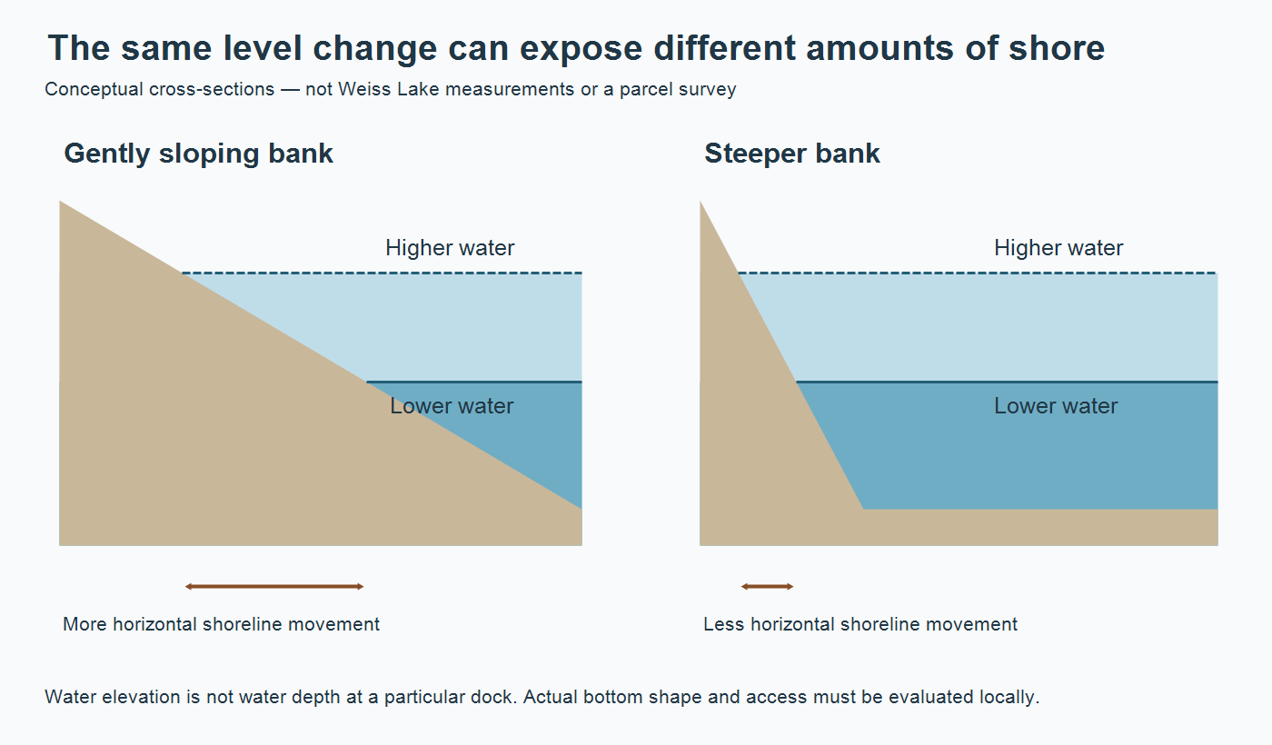
Lake elevation and local water depth answer different questions. Elevation describes the water surface relative to a reference level. Depth is the vertical distance from that surface to the bottom at a particular point. A lake-wide reading therefore cannot establish the depth beneath a boat, at the end of a pier or along the route out to open water. The bottom between those points matters too.
For example, a photograph may show water around the outside of a dock while leaving the route back into the cove invisible. That is a reason to investigate the whole intended use, not to declare the dock usable or unusable from the image. Obtain property-specific information from an appropriate local professional; do not wade into unfamiliar water or operate a boat to test an assumption.
Compare the property with the lake routine you actually want
I would make the intended use explicit before comparing homes. “We want a lake view” and “we want to leave this particular boat in the water through winter” are not interchangeable requirements. Here is a practical way to separate the evidence each choice needs.
| Your priority | Useful evidence | What that evidence cannot settle alone |
|---|---|---|
| A view through different seasons | Dated photographs from the same viewpoint, including lower-water conditions | Current dock condition or navigability |
| Using a particular boat from a dock | Property-specific depth and access assessment tied to the boat and observed level | Future levels or permission for alterations |
| Trailering to public access | The named ramp, its operator and current access information | Availability at every water level or space when you arrive |
| A seasonal or occasionally vacant home | A separate home-care and service plan | Shoreline access, which remains its own question |
For a fair comparison, keep the date beside every photo or observation. A July picture of one home and a November visit to another can be useful, but they are not a like-for-like test of shoreline appearance. Ask for missing seasonal evidence rather than treating the more flattering image as the more informative one.
Keep physical condition, authorization and suitability separate as well. A structure being present does not answer whether it is in good condition, whether its documents fit the current arrangement, or whether it serves your intended use. Bring those questions into the purchase process early enough for the appropriate property and contract professionals to investigate them. Do not assume that extending, dredging or modifying something is automatically available as a solution.
A public launch can be a different kind of lake plan
ADCNR describes Weiss as an Alabama Power hydroelectric reservoir on the Alabama–Georgia border and identifies both public access and privately operated marinas. A home search does not have to begin with the assumption that every outing starts at your own shoreline. If you expect to trailer a boat, compare the drive, the actual launch arrangement and your storage needs as a separate routine.
The state’s Freshwater Boating Access map lists access points managed by its Wildlife and Freshwater Fisheries Division; it does not include every access point managed by someone else. Open the official ramp map or linked list view, select the named facility and use its own details. A missing pin is not proof that no other operator has access nearby. Equally, a pin is not a promise that a ramp is suitable for your boat or conditions that day.
Connect the shoreline question to the rest of the home
The water outside the house and the drinking water inside it are separate systems. If a property uses a private well, the Centre and Cherokee County well-records and testing guide explains which reports, equipment details and local testing contacts belong in the handoff. A lake address does not establish the home’s drinking-water source.
For an autumn move or a home that will stand empty at times, the North Alabama first-freeze checklist addresses exposed plumbing and other household preparations. That is a useful companion task, not a substitute for shoreline information. Keep both sets of records so a later question starts with something more reliable than a remembered conversation.
Alabama Power’s seasonal article also explains how to set lake-specific notifications in its Shorelines app. Select the lake and the level, generation or update notifications that matter to you. Notifications help you notice a change; they are not an inspection of your property or a guarantee of safe access.
Conclusion: choose the home and the water routine together
Weiss Lake can be part of a very appealing daily life, but the useful comparison goes beyond a photograph of blue water. Decide how you intend to use the lake, collect dated evidence for that use, and keep seasonal operation separate from property-specific depth, structure condition and permission. You can then compare homes on the routine you actually want rather than on an assumption hidden inside the word “waterfront.”
Want Personalized Real Estate Help?
If you are considering a home around Weiss Lake or elsewhere in Cherokee County, I can help organize the real-estate questions around the way you want to live. Contact me to talk through your home search, the records worth gathering and which questions belong with the appropriate local specialist.
Explore properties around Centre and the nearby Weiss Lake area. This is one starting area, not a search of the entire lake or waterfront-only homes. Check shoreline access, seasonal water conditions and permissions for each property separately.
Sharing is Caring:
Author