A river view can be one of the pleasures of looking for a home around Florence. A creek at the back of a lot can look like a quieter version of the same idea. But neither the view nor the distance from the Tennessee River answers the question a buyer actually needs to settle: what do the records say about this building, this piece of land and the plans you have for it?
Start with three separate conversations: the official flood map, the local development requirements and the insurance coverage. Bringing the same property information to each conversation helps you compare answers. It also keeps a reassuring-looking listing photograph from doing a job that belongs to maps, records and qualified professionals.
Start with the effective map, not a listing thumbnail
ADECA directs Alabama property owners to official flood mapping and explains that effective FIRM panels and Flood Insurance Studies are available alongside other mapping products. Its Alabama floodplain lookup guidance is a useful starting point. For a purchase, ask which effective map and any subsequent official map-change documents apply to the address; a preliminary layer or an undated screenshot should not silently stand in for that answer.
Save the property address, parcel identification, map panel or product reference, effective date and the date you looked it up. Mark which building you mean if the property has a detached garage, workshop or more than one residence. If a seller has an elevation certificate, survey or official map-change letter, request a copy early enough for the appropriate professional, lender or insurance agent to review it. A document with the right street name but the wrong structure is not the answer you need.
For a local starting point, the Lauderdale County Road Department page links its Flood Plain Map. Use that official route rather than a similarly named county in another state. A county viewer is useful for orienting yourself; ask the responsible office which underlying effective records should guide a decision when layers or dates differ.
A parcel boundary is not a building footprint
Imagine a lot whose rear edge crosses a mapped flood-hazard area while the house sits toward the front. Now imagine a different lot with its house inside that mapped area. A pin dropped at the driveway, or a statement that some portion of the land intersects the shading, does not describe both situations equally well. The useful next question is where the actual structure sits in relation to the mapped boundary, supported by the appropriate records.
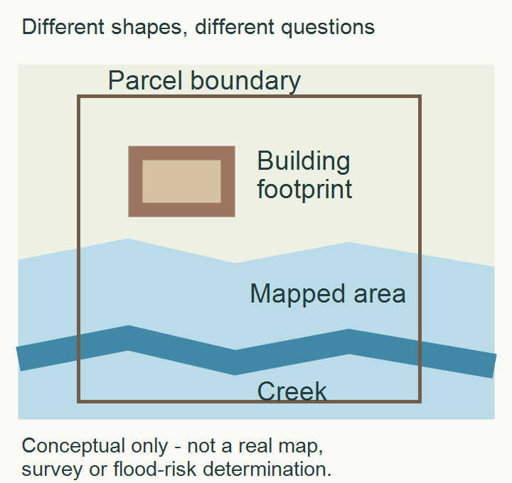
That distinction matters for future plans, too. A house location and the spot where you would like to add a workshop, grading or another improvement are different questions. Do not infer that an existing home settles whether a proposed project is allowed. Take a marked site plan to the permitting office before treating usable-looking open ground as available building space.
FEMA defines the one-percent-annual-chance floodplain by a flood with a one-percent chance of occurring in any given year. The familiar “100-year” wording is not a schedule that gives a property a century between events. Likewise, a base flood elevation is referenced to a vertical datum; it is not automatically the depth of water above every yard. Ask a qualified professional to interpret elevation records rather than subtracting an app reading from a map number.
Use the right local office for the property and the project
Florence states that proposed construction within a flood hazard area requires a special flood hazard development application and permit. The city permit guidance also identifies elevation certificates and no-rise certificates among the documentation involved. Ask the department what applies to your particular proposal; that wording does not mean every buyer should commission every type of certificate.
A Florence mailing address is a starting point for a conversation, not proof of permitting jurisdiction. The city page describes its planning jurisdiction and explicitly lists nearby communities where it does not issue permits or perform inspections. Tell the office the exact parcel and the work you have in mind, then confirm the responsible jurisdiction before ordering plans. Avoid treating county boundaries, city limits and a postal address as interchangeable.
The local emergency-management directory routes flood-plain questions to the Lauderdale County Road Department at 256-760-5880 and Florence planning-jurisdiction building-permit questions to 256-760-6325. Keep the official department directory with your records so you can check contact details when you need them.
Bring a small, organized record set to the conversation
| Bring or request | Question it helps resolve |
|---|---|
| Address, parcel ID and a marked building location | Are we discussing the same land and structure? |
| Effective map reference, date and any official map-change record | Which published information applies, and is a newer or different layer being confused with it? |
| Existing survey or elevation certificate, if available | What measured information can the qualified reviewer use? |
| A sketch of a proposed addition, grading or outbuilding | Which local approvals and supporting documents would that project need? |
| An insurance quote with coverage, deductibles and effective date | What is actually covered, and when does that protection begin? |
For example, if you are comparing two homes and one has an older elevation certificate, do not treat possession of the certificate as a favorable result by itself. Check that it describes the structure being purchased and give it to the people interpreting the current transaction. If the other home has no certificate in the seller’s files, ask what information is needed; absence from that file does not establish the property’s flood status either.
Keep the insurance question separate from the map question
FloodSmart explains that most homeowners policies do not cover flood damage. Ask your insurance agent about the specific property and coverage rather than assuming a standard policy answers the concern. Under the NFIP, building and contents coverage are separate coverage choices, and the usual waiting period is thirty days with specified exceptions. Read the official policy-buying guidance and confirm the actual effective date for your transaction; do not assume an exception applies or wait until closing day to ask.
A useful quote discussion includes what building and belongings are covered, deductibles, exclusions and when coverage starts. A lender’s requirement and your own coverage decision are not interchangeable questions. I can help keep these requests organized within the home-search timeline, while your lender, insurance professional and local officials answer the questions within their roles.
Look at everyday drainage as well
The map review should not replace a closer look at the home’s ordinary water-management details. A downspout ending against the wall, an unknown buried drain or a yard that funnels runoff toward a foundation deserves its own inspection question. Those observations do not establish a FEMA zone, and a map result does not explain every drainage concern.
The related North Alabama roof-runoff and downspout guide shows how the outlet and surrounding ground work together. Use it to prepare specific observations for an inspector or drainage professional, while keeping the official flood-map and permitting record set separate. That gives you a more complete picture without asking one source to prove something it cannot.
Conclusion: make the records useful before making assumptions
For a Florence-area purchase, the goal is not to become a floodplain specialist in an afternoon. It is to identify the right property and structure, use the applicable records, and bring a clearly described project or coverage question to the right person. That approach works whether the feature that caught your eye was a river view, a creek or simply a spacious yard.
Keep copies of the answers with the documents you use to compare homes. Specific information about the property is much more useful than a broad “near the water” label—and it gives you a clearer basis for deciding what to investigate before moving forward.
Want Personalized Real Estate Help?
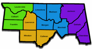
If you are beginning a Shoals home search, Browse Florence-area homes to explore the area. The map also reaches nearby communities; it is not a city-boundary, flood-zone, insurance or buildability filter. Each property needs its own review.
Buying or selling in Northern Alabama? Contact me and we can organize the property questions, records and next steps around your plans. My role is to help you connect the home decision with the right local information and professional guidance, without letting important details get lost between the showing and closing.
Sharing is Caring:
Author