
When you are getting to know Athens, a walk can answer a small but useful housing question: where would you actually go on an ordinary afternoon? A trail name on a property search map does not tell you where to start, whether the outing returns to your car, or how much time to leave for getting back.
Around Swan Creek, begin by separating two connected choices: a recreation loop with a published lap distance and a greenway corridor with several access points. They can fit different routines. Here is how to plan a first visit without confusing a loop, a one-way walk and a future trail proposal.
A loop and a corridor make different outings
The City lists the Athens Middle School Track as a 1.53-mile circuit around the school and Swan Creek Park. The tourism office calls this the Athens Recreation Loop and identifies access from the Recreation Center, Swan Creek Park and the greenway. Its listed lap distance makes a useful planning unit: two complete laps total 3.06 miles, before any walk from your parking spot.
The Swan Creek Greenway description instead runs from the SportsPlex toward U.S. 72. Swan Creek Park is an intermediate access point. A City 2023 walk announcement describes the choice from that park as north toward the SportsPlex trailhead or south toward the U.S. 72 trailhead. That older event is over; the directional description is the useful part here.
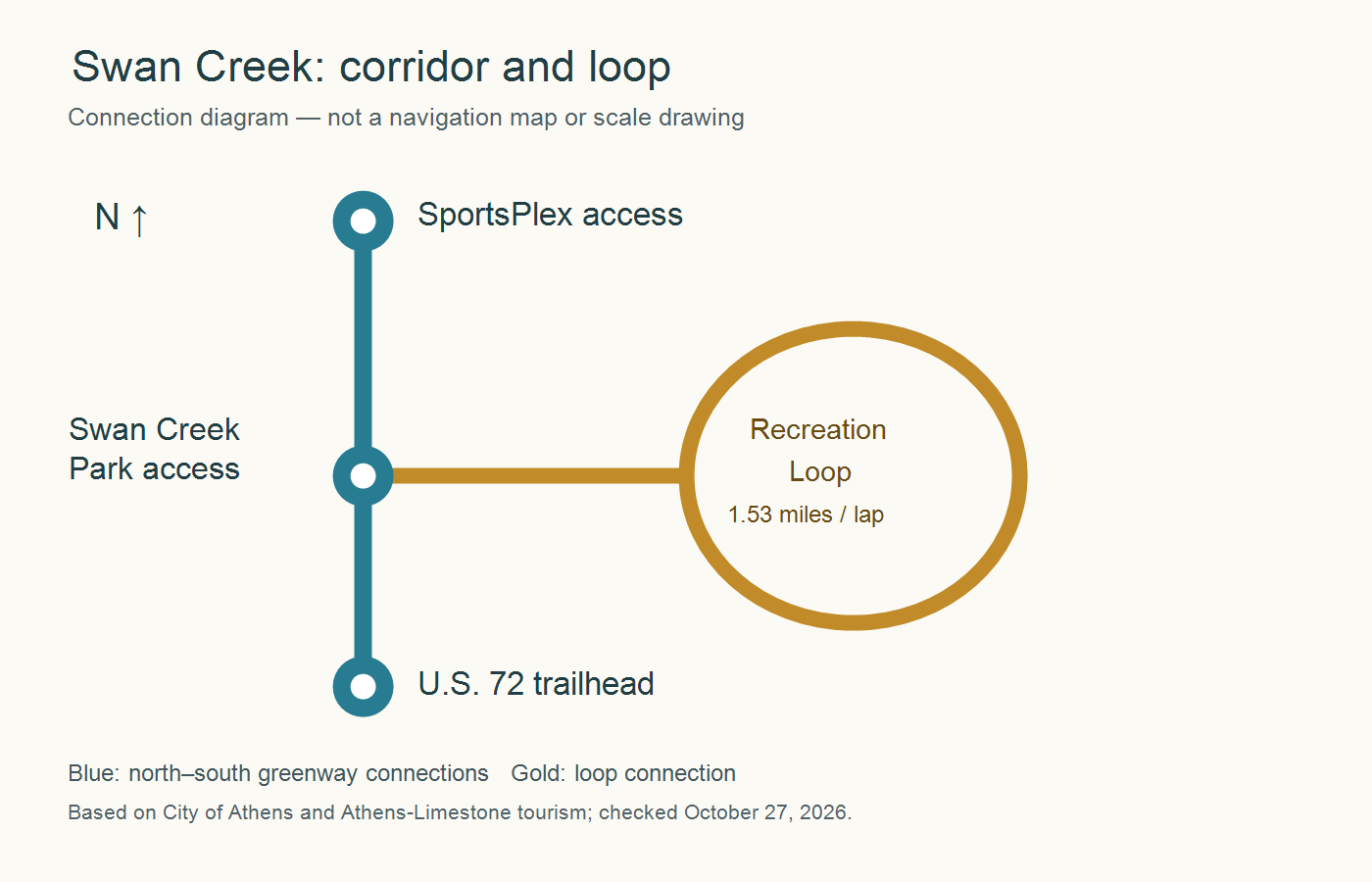
The diagram shows connections, not the shape of the path. If you want to finish where you began, choose the loop or deliberately plan your return along the corridor. Arriving at a different trailhead is not the same as arriving back at your vehicle. Do not add the published loop distance to an old greenway total and assume that is the route you will walk.
Choose the entrance that fits the visit
The tourism page gives three useful starting choices. At the SportsPlex, it directs visitors to the southwest corner for the trailhead. Swan Creek Park offers access midway along the corridor and to the track, playground and pavilion. For the southern trailhead, the description directs visitors through the Lowe’s turn-in and east along the access road; follow current signs rather than stopping along the highway.
| What you want to do | Useful starting choice | Plan the return |
|---|---|---|
| Repeat a known lap | Recreation Loop access | Count complete laps; allow for the connection from parking. |
| Try a shorter creek-side outing | Swan Creek Park | Choose north or south and a turnaround point. |
| Begin at one end of the corridor | SportsPlex or U.S. 72 trailhead | Return on the same path unless you have arranged another way back. |
Save the actual destination before leaving: Athens SportsPlex, 1403 US-31, Athens, AL 35611 or Swan Creek Park, 100 U.S. Highway 31N, Athens, AL 35611. These are facility destinations, not a promise that a navigation pin identifies the exact parking space or path entrance. The City’s track listing supplies 21281 Sportsplex Loop, Athens, AL 35611; use its facility information when arranging that visit.
Make the first outing a small experiment
A first visit does not need to cover the entire corridor. For example, someone with 40 minutes available could reserve time for parking and getting oriented, walk away from the chosen entrance for ten minutes, and turn back. The return may take longer if you pause or meet different conditions, so leave a margin. That is a planning example, not a measured trail-time estimate.
The tourism description identifies crushed stone and welcomes walkers, strollers and bicycles. That does not establish that every wheel, mobility device or person will find every section comfortable in every condition. On your first visit, examine the surface and transitions you actually intend to use. A short trial with your own equipment tells you more than the word “greenway” alone. If specific accessibility features are essential, ask the Recreation Department about that section before making the trip.
Bring the ordinary details into the decision: where you parked, the entrance you used, whether you stayed on the loop or corridor, and how the return fit your available time. A repeatable 25-minute outing may serve your week better than a longer route you rarely have time to complete. Neither choice makes one part of Athens universally better for everyone.
Do not read a planning map as an opening announcement
Search results also surface the Singing River Trail Athens Action Plan. Its cover is dated February 2022, although the file is hosted in a 2025 upload folder. The plan distinguishes existing trail from proposed and future alignments, including connections toward downtown and farther south. Those lines express a plan; they do not independently establish a continuous open walking or cycling route today.
Similarly, the City’s October 2020 grant announcement describes a 2.3-mile greenway and an additional 1,200 feet associated with a then-under-construction trailhead. It is useful history, not a fresh measured distance for every present-day outing. This guide therefore uses the City’s current facility listing for the recreation lap and named access points for the corridor, rather than advertising a new total created from old figures.
If a proposed connection is important to your housing decision, keep it in a separate column from the route you have actually used. Look for an operator’s opening notice and confirm the entrance and permitted use. A future line near a house is not evidence of public access from the lot, an easement across neighboring land or a finished crossing.
Turn a pleasant visit into a useful home comparison
Once you know the outing you like, compare the complete trip from a candidate home: getting to the public entrance, parking or reaching it on a permitted walking route, completing the outing and returning. Measure the trip you make rather than drawing a straight line from the house to the creek. Do not assume a nearby cul-de-sac connects to the greenway or that an apparent shortcut is public.
For a different part of town, the tourism office’s Fitness Park description identifies a west-Athens alternative near the medical district, with fitness stations, a playground, pavilion and rolling terrain. That is a separate outing to investigate, not a claimed off-road connection to Swan Creek. Choose it because its location fits your actual routine, not because all paths in Athens share one continuous network.
When an otherwise promising home needs changes to work for you, the next question is different again. My Athens home-project guide explains how to identify the property’s jurisdiction and separate land-use review from construction questions. Enjoying a nearby public route and being able to make your planned home alteration are two independent parts of the decision.
Sources checked October 27, 2026. Route conditions and facility access can change. Featured image is a conceptual AI illustration; the connection diagram is an original explanatory graphic, not a navigation map.
Final Thoughts
Start with the outing you would genuinely repeat: a measured lap, a short creek-side walk or a longer corridor visit with a return plan. Choosing the entrance and return first makes the experience easier to judge. Then bring that complete routine into your home comparison, while keeping proposed connections and private-property access separate from what exists today.
Want Personalized Real Estate Help?
If an everyday outdoor routine is part of your Athens-area move, I can help you connect that priority with the rest of your home search. Explore homes around Athens and nearby communities as a starting point. This broad area search includes surrounding locations; it does not filter for trail access, walkability or a particular travel time. Contact me about buying, selling or relocating, and we can organize the property and location questions that matter to you.
Sharing is Caring:
Author