
A nearby greenway can change an ordinary weekday: a walk before opening your laptop, a bike ride after work, or somewhere to stretch your legs between errands. But when you compare homes around west Huntsville and Madison, the useful question is not simply whether Indian Creek appears nearby on a map. It is which section you can actually reach, where you would enter it, and whether that outing fits the time you have.
Indian Creek is a good example of why those details matter. The city describes north and south sections separately. A neighborhood name, a green line behind a property or an older planning map should not become a promise of one continuous route. Here is how to make a realistic first visit and use it to ask better questions about the routine you want.
Jump to the section comparison, the locator map, or the home-search test. The featured watercolor is an AI-generated illustration, not a photograph of this trail.
Choose the section before choosing a distance
The City of Huntsville’s Indian Creek Greenway page lists the southern section between Old Madison Pike and Creekwood Park at 2.95 miles, and the northern section between U.S. 72 and Providence School at 0.82 mile. Treat those as the city’s listed section lengths, not as a loop distance or a survey of your route from a particular parking space.
| First-visit choice | Listed section | Plan the return |
|---|---|---|
| Longer southern corridor | Old Madison Pike to Creekwood Park: 2.95 miles | Full length and retracing it: 5.9 miles, before any parking approach. Choose an earlier turnaround for a shorter outing. |
| Shorter northern section | U.S. 72 to Providence School: 0.82 mile | Full length and retracing it: 1.64 miles. This does not establish public access through school property. |
Those return distances are simple calculations from the published lengths, not independently measured routes. If you have a short break, an out-and-back with a deliberate turnaround is easier to control than setting out toward an unfamiliar endpoint. Decide how much time you can spend before leaving; reaching the end of a named section will not necessarily put you near your car.
Match the entrance to the errand, not just the neighborhood
Huntsville identifies parking at Old Madison Pike, Creekwood Park and the Village of Providence. For an initial visit, choose one named access area and inspect the route to that place. Open Creekwood Park in Google Maps or locate the Village of Providence for orientation. A general place result is not a guarantee of a particular legal parking space or trail entrance.
The City of Madison’s greenway directory adds useful local context: Indian Creek follows the Huntsville–Madison border, with access off Old Madison Pike near Slaughter Road and behind the Creekwood subdivision north of the Farrow Road–Slaughter Road intersection. It identifies Huntsville as the managing and maintaining city. That distinction matters when a search result says Madison but you need the agency responsible for the path.
Make the first visit a small experiment. Note the actual approach from public parking, any crossing you must make, the surface and grade you encounter, and where you could comfortably turn around. Someone walking, pushing a stroller, using a mobility device or starting a bike ride may notice different constraints. A greenway listing alone is not a site-specific accessibility assessment. This guide has not inspected current surface conditions, closures or amenities at each entrance.
Read the corridor without inventing a connection
The locator below shows the geographic relationship between mapped Indian Creek paths and nearby roads. The gap between the mapped path groups is intentional: no connecting trail has been drawn to complete a reassuring-looking line. It helps you orient north and south; it does not route you through the gap.
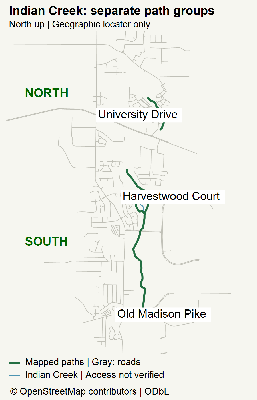
There is another reason to read map legends closely. The map linked from the city’s trail page is dated August 2012 and distinguishes existing and proposed routes. It is useful historical context, but a proposed line on that sheet is not evidence that a connection opened. Huntsville’s greenway directory and planning page also separates facilities from its broader network plan. Use current facility information and posted conditions rather than adding every planning line to your outing.
Here, the municipal descriptions establish the named sections and access context; OpenStreetMap supplies independently licensed background geometry. They serve different purposes. Neither this locator nor the old plan establishes a private parcel boundary, a right of access through a neighborhood, or an off-road connection to your workplace.
Turn nearby into a useful home-search question
Imagine two hypothetical homes. One looks closer to the creek in an aerial view, but its practical public entrance is on the other side of a road connection. The other is farther from the green line but has an approach you are comfortable using. The first is not automatically the better fit. Compare the actual door-to-entrance trip you would make, not a straight-line distance or a listing’s broad proximity wording.
During a visit, keep three separate notes: the trip from the home to public access; the portion of the path you would realistically use; and the return to your next commitment. If a route depends on a private gate, an informal worn track or school grounds, do not count it as available access without appropriate confirmation. Ask property-specific questions about recorded access and restrictions through the normal purchase process.
The same distinction applies to commuting. A recreational path near an employment area is not proof of a continuous bike commute. If you intend to combine walking with public transportation, the Huntsville Orbit and Access newcomer guide helps you work through service type, schedule and eligibility questions. Check the actual stop-to-destination connection separately; this article does not establish an Indian Creek transit interchange.
For a seller, describe a verified public amenity accurately without turning nearby into a promised walking time, private entrance or universal lifestyle benefit. For a buyer, an ordinary weekday visit can be more revealing than a map screenshot. You are looking for a routine you can repeat, not a feature you only admire online.
Final Thoughts
Indian Creek offers a practical way to test what greenway proximity means to you. Start with one listed section, identify a real public access point, and build an outing with a manageable return. Then bring what you learned back to the home search. A location becomes more useful when you understand how you would actually use it.
Want Personalized Real Estate Help?
Explore Huntsville-area homes if you would like a starting point for comparing locations. This is a broad area search, not a greenway-access filter or a complete Greater Huntsville inventory. For each property, check the actual public entrance and the trip you would use separately.
Thinking about a home around west Huntsville or Madison and hoping a greenway will become part of everyday life? Tell me about the routine you want to build. I can help you compare locations and organize property-specific questions around work, errands and outdoor time, without assuming every home near the creek offers the same access.
Sharing is Caring:
Author