Jessica Hassan
Joe Wheeler State Park offers short paths near its lodge and day-use facilities as well as longer trail sections elsewhere in the park. For a first outing from the Rogersville area, the useful question is not simply “Which trail is best?” It is how far you want to go, where that route actually starts, and whether the park has described enough about its terrain for your group.
The park lists approximately 16 miles of dog-friendly hiking and biking trails, but its named paths do not all share one parking lot. Pick a route first; then use the official two-page trail map to locate its trailhead. The map is a planning aid, not a live closure notice.
Choose a first route by distance and starting point
- A very short loop: Day Use Loop, 0.4 mile. Near Pavilion #1 in the Day Use Area
- A short lodge-area walk: Champion Trail, 1 mile. West end of the lodge parking lot
- A short trail by the creek ramp: Samuel Hardin, Sr. Loop, 0.6 mile. Extra parking lot northeast of the 1st Creek Boat Ramp
- A longer marina-area section: Luther’s Pass, 2.5 miles, or Page Farm Trail, 2.9 miles. The Awesome Trail starts near the marina; confirm your chosen section on the park map
- A three-mile outing away from the lodge side: Multi-Use Trail, 3 miles. North of Highway 101, across Wheeler Dam
These are the park’s listed route lengths, not a promise about the total distance you will walk from your car or after connecting sections. Its trail page gives elevation endpoints, but does not publish a consistent difficulty rating, cumulative climb, surface description, or accessibility standard for each route. A 0.4-mile path may still be unsuitable for a particular visitor. If grades, roots, mobility access, or biking conditions matter, ask the park about the exact route rather than treating mileage as a difficulty score.
Avoid the wrong entrance
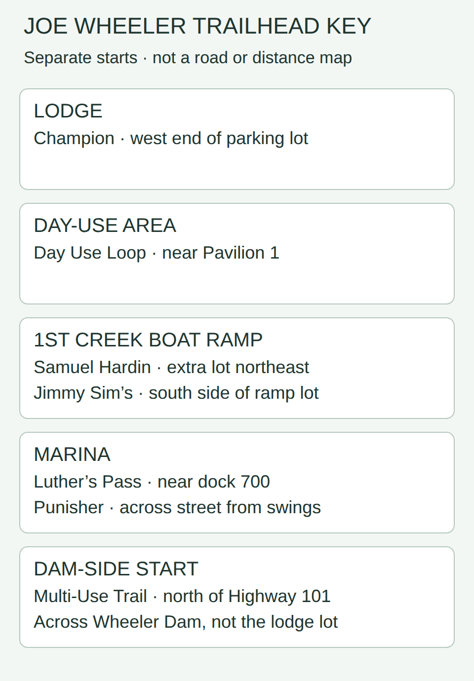
Trailhead orientation key, not a road map. Lodge: Champion starts at the west end of the parking lot. Day use: Day Use Loop starts near Pavilion 1. First Creek Boat Ramp: Samuel Hardin loop starts in the extra lot northeast of the ramp; Jimmy Sim’s Birding Trail starts at the south side of the ramp lot. Marina: Luther’s Pass starts near dock 700; Punisher starts across the street from the swing set. Dam-side: Multi-Use Trail starts north of Highway 101 across Wheeler Dam. These are separate starts, not one continuous route.
The park’s main page lists 4401 McLean Drive, Rogersville, AL 35652-2916 for the park and lodge. That is a lodge destination, not a universal trailhead address. Match your selected start in the key to the official map before setting directions; the lodge address alone will not take you to every trail.
The park also lists Wheeler Village Trail entrances near cabins 24, 9, and 15; Campground Trail by the playground past the campground store; and Elk River Trail off Elk River Park Road. Those may be good choices when you are already visiting those facilities. The park does not publish a separate street address for each start on its trail page, so use its map and call for directions if the turnoff is unclear.
What to verify before you set out
Read the current park trail list and map together, then call the park office or lodge at 256-247-5466 if weather, a closure, a damaged segment, parking, biking access, or a mobility need could change your choice. The day-use area has its own admission and pavilion information; check that page if your chosen route starts there. A trail listing alone does not establish what you will pay to enter a particular facility on your visit date.
The park says its trails are marked with colored blazes and close at dusk. It recommends suitable footwear, water, and a map or directions; it also warns that cell service may be spotty. Plan enough daylight for the return and tell someone which trailhead you chose. If you are biking, check the selected section and current trail etiquette with the park rather than assuming every named path has the same conditions.
Make the trail part of a Rogersville-area day
A short lodge-area walk and a picnic are different planning decisions. If you are meeting others afterward, my Joe Wheeler pavilion and admission guide explains how to separate a shelter reservation from guests’ entry costs. It does not replace the trail map or confirm today’s trail conditions.
Final Thoughts
For a first visit, start with a distance you want to walk, then match it to the trailhead: Day Use Loop for a brief day-use circuit, Champion for a lodge-area mile, Samuel Hardin for a creek-ramp short loop, or a longer Awesome or dam-side Multi-Use section if that is the outing you intended. Verify the entrance, current conditions, access needs and daylight with the park. The official map is the final route reference; the main lodge address alone is not directions to every trail.
Want Personalized Real Estate Help?
Exploring the Rogersville area as a possible home base? I can help you compare the places you enjoy with the practical details of particular homes. Tell me what matters in your move.
You can also browse Rogersville-area homes. Listings and map boundaries can change; this search does not filter homes by park access or trail conditions.
Sharing is Caring:
Author

Sources and review notes
Official Alabama State Parks pages checked November 6, 2026. The featured image is an AI-generated illustrative wooded lakeshore path, not a photograph of Joe Wheeler State Park or a route map.